Copacabana
Our first stop in Bolivia was Copacabana (approx. 6000 inhabitants) which is nestled between Mount Calvario and Mount Niño Calvario and is the main Bolivian town on the shore of Lake Titicaca.
Copacabana was known as a pilgrimage site – nowadays it is still famous for Fiestas such as the Fiesta De la Virgen de Candelaria where pilgrims of Peru and Bolivia perform traditional Aymara dances. We were told that there are some interesting sights that can be visited here such as the Virgen de Copacabana – the Virgen is said to be the protector of the drivers. Unfortunately, I am not able to give you more information about it because it was raining and windy and therefore we spent the rest of the day taking a short stroll around the lake and the main road. Please be aware that due to the altitude it can get chilly during the night.
Isla De La Luna (Island of the moon)
The day after a short boat trip took us to Isla de La Luna (Island of the moon) which is said to be the location where the moon rose and famous for the Temple of the Virgins.
Isla Del Sol (Island of the Sun)
Our next stop was Isla del Sol (Island of the Sun – there are two boats departing from Copacabana at 8:30 and 13:30 but please check because maybe times have changed during the years – tickets can be bought at the kiosk close to the port or at one of the many tour agencies you will find in Copacabana).
This island is important due to the fact that in the Inca mythology it is the birthplace of the sun. We had a nice walk around this unmotorized island. This island is said to be the birthplace of the sun.
Around 800 families live here in several villages (Yumani and Challapampa are said to be the largest once). The island contains over 80 ruins – most of them are said to be remnants of the Inca civilization of the 15th century. With so many things to explore you can also stay overnight but please be aware that I was told that the accommodations are rustic therefore if you decide to stay overnight please don´t expect to find a luxury hotel.
We did a lovely hike around the island passing by terraces, small shops till we arrived at the highest point of the island (4000m a.s.l. – you could experience altitude sickness) before finishing our hike at the Inca Stairs that can be found at the entrance of Yumani village and that will lead you down to the port. If you happen to be hungry after the hike you will find a lovely restaurant with all the facilities, you might need.
To gain some time, we decided to leave Copacabana on the same evening. The journey to La Paz was quite interesting due to the tiny boat we had to embark to cross el estrecho de Tiquina – personally I found it lovely.
The Pico De Austria Hike
The Pico De Austria Hike was the program of the next day which is a fantastic trek through gorgeous landscapes. The hike is challenging – or at least I do think that it is challenging.
You start at the Rinconada 4.400 m. The first part of the trail is easy with gradually climbs in altitude. From the small lake of Khauna Khota before and the Laguna Chiar Khota (4700m) after you have good views of Condoriri – a mountain in the Cordillera Real of Bolivia at about 5,648m of height. The Laguna is the beginning off the climb towards the Pico De Austria.
Unfortunately, by the time we started climbing it started to hail and the trail was getting slippery. By the time we reached the ridge (took me ages because I kept slipping) the weather kept on getting worse and beside the hail it was very windy. My guide told me it would take at least another half an hour to reach the summit, but I was not comfy with the weather and therefore I decided to go back down. I do not regret my decision even though I really wanted to get on to the summit – as said the views were simply gorgeous therefore I can´t imagine how gorgeous they are on the summit. Said that with such a weather I am not sure I would have seen much – therefore I simply will be back someday to finish this awesome trek.
There are loads of interesting hikes in this area – if you have time I do recommend stopping a few days in this area – I am pretty sure you won´t regret it.
The Salar De Uyuni (3 Days/2 Nights)
We spent the rest of the day/night on a bus to Uyuni because the day after we had a 3 days tour starting with obviously the Salar De Uyuni being a stop. To be honest with you the only reason why I had decided to visit Bolivia was the Salar De Uyuni – but I must admit that this tour made me reconsider Bolivia. I have to admit that everything we saw during this trip was simply amazing and I am glad I decided to go for it. So, if you think that Bolivia is just the Salar De Uyuni as I did – you are definitely wrong. Bolivia has gorgeous landscapes, beautiful and interesting places beside the famous Salar De Uyuni.
Train´s graveyard
Our first stop was at the train’s graveyard to see the first locomotives in Bolivia. This is an open-air museum of rusted out relics from the time when railway was a big business in the region. In the 19th century, British engineers came to Bolivia and with the Antofagasta and Bolivia Railway Company they started building an extensive railroad to carry minerals from La Paz to Chilean ports on the Pacific Coast. When the mining industry declined in the 1940s everything was abandoned.
Colchani Village
Afterwards we went to the small village of Colchani famous for the Salt processing plants. In fact, after the salt has been extracted and has dried out in the sun – it gets transported to Colchani where it is then cooked in ovens to dry further, iodine is added next and there it is the salt that everybody uses.
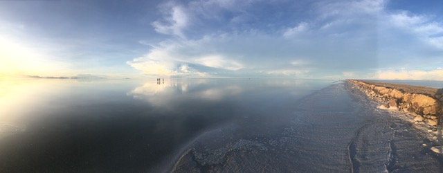
Salar De Uyuni
The highlight of this trip as said before was the Salar de Uyuni which with his 12000qm is the world’s largest salt flat. It is a 10000years old death lake (at an altitude of around 3660m a.s.l.) surrounded by extinct volcanoes and 32 islands in it.
The Salar was formed because of transformations between several prehistoric lakes. It is covered by a few meters of a flat salt crust. The crust serves as a source of salt and covers a pool of brine, which is exceptionally rich in lithium. It also contains sodium, potassium and magnesium. The area has an average temperature with November to January being the warmer months with a peak at around 21 °C and June being the coldest one with around 13 °C. The nights are cold throughout the year, with temperatures between −9 °C – 5 °C.
We did a long drive on the Salar taking loads of pictures. I must admit that it looks exactly the same as it looks on the photos you see on books or on the internet. It is spectacular.
We spent the night at the small village of Atulcha. Our group was lucky because we made it to the accommodation – one of the jeeps got stuck in the salt and the guys had to walk to the accommodation. The three guides spent almost the entire night to get the car out of the salt to be able to continue the trip the day after.
Desert of Chiguana
The day after started with the small desert of Chiguana south of De Salar De Uyuni which is surrounded by many dormant volcanoes and dominated by the 5840 high Ollagüe volcano. From the lookout you have gorgeous views of the Ollagüe volcano and its fumarole.
La Reserva De Fauna Andina “Eduardo Avaroa”
La Reserva de Fauna Andina “Eduardo Avaroa” which was established in 1973 and named after Eduardo Avaroa (1838–1879 – a Bolivian war hero of the 19th century) has plenty to offer.
Desert of Siloli
The big desert of Siloli at an altitude of 4550 (said to be the highest and driest of the world) and its famous Arbol de Piedra (the rock tree) was another stop.
Laguna Colorada & its pink flamingos
Along the way and before arriving at the Laguna colorada (Red Lagoon) we stopped at other lagoons to see flamingos and other birds. The amazing Laguna colorada and its pink flamingos where definitely another highlight of the day.
- The Andean flamingo is one of the rarest flamingos in the world. It has a pale pink body, a black and yellow large and curved bill, yellow legs, bright upperparts and a distinctive large black wedge or triangle at the rear of the body.
- Young birds are gray until they develop the adult pink plumage.
- They are very gregarious and feed in small groups meters apart.
- These animals are filter feeders, they are monogamous and breed in December and January laying one egg. Both male and female incubate the egg for 27-31 days, and both care for the young which will gain sexual maturity and their full adult plumage at 3-6 years of age.
Sol De Manana
Sol de Mañana (around 4850m in height) was our last stop of the day. This geothermal area characterized by intense volcanic activity and the Sulphur springs field is full of mud lakes and steam pools with boiling mud. This place is also characterized by a very bad smell due to the Sulphur.
Salvador Dali Desert
The first stop on our last day was the Salvador Dali Desert named after the Spanish painter Salvador Dalí because similar to some landscapes he painted even though he did not know anything about it. Here we were lucky to see vicuñas into the wild.
Green Lake
Our last stop before heading back to La Paz was Green lake at the foot of the volcano Licancabur (6000 high). The color is due to the high content of arsenic and other minerals (6000 high).
Please be aware that most tour operators can organize a transfer to the Chilean border. A mini bus will get you to San Pedro de Atacama.
La Paz
On our last day of this gorgeous trip we visited La Paz (highest governmental capital of the world – Sucre the judicial capital) founded by Alonso Mendoza in 1548 following the discovery of Gold in the Rio Choqueyapu. La Paz is in the valleys of the Andes, close to the Eastern split of the Altiplano region.
It has a Cable car system – called Mi Teleférico (“My Cable Car”) that was opened in 2014. Currently eight lines are in operation, and three more lines will be added. All stations have both a Spanish name and an Aymara name. While travelling on the cable car we were told that the altitude of La Paz is marked by social differences: wealthy residents live in the lower, central areas of the city southwest of the Prado/ middle-class residents in high-rise condos near the center while lower-income residents live in makeshift brick houses in the surrounding hills.
The whole city has rainy summers and dry winters. Night-time temperatures range from cold to very cold. Due to the altitude of La Paz (4058 m a.s.l.) temperature are cool to mild throughout the year, though the diurnal temperature variation is typically large.
Plaza Murillo
We started the day with the central plaza of the city Plaza Murillo designed by Juan Gutierrez Paniagua – the name was given on February the 3rd 1902, in honor of Pedro Murillo, captured and hung by Spanish troops in January 1810. It has been a key site for battles for political power in Bolivia with many Independence leaders killed on or near the plaza- the last one being held in 2002.
This beautiful plaza is home of the Presidential Palace known by the nickname Palacio Quemado (Burned Palace) which is a reference to its fiery past – Outside there are guards dressed in their 19th century uniforms, commemorating the soldiers who fought against Chile during the Pacific War.
The National Congress of Bolivia with its clock in the spire that runs anti clockwise and the Cathedral of La Paz also called The Cathedral Basilica of Our Lady of Peace (Catedral Basílica de Nuestra Señora de La Paz) are other buildings that can be found in Plaza Murillo. The cathedral was first completed in 1692 (after 70 years of construction) – due to the threatened of collapsing it was demolished and rebuilt (1835-1925). In 1989, its two lateral towers were opened, this event coinciding with the visit of Pope John Paul II.
Mercado De Hechiceria
Our second stop was Mercado de hechiceria (the witch market) were we found some lovely presents to bring back home. Here you can find a lot of things such Herbal tea fusions, homeopathic folk cures, coca leaves, amulets along colorful alpaca sweaters and woven textiles.
Basilica De San Francisco
In the afternoon we went to see the Basilica de San Francisco which was built between the 16th and 18th centuries.
Valle De La Luna
We then took the Cable car to El Piano and then we went to Valle de La Luna (Moon Valley) which is situated at about 10km from downtown La Paz. Our guide told us that the name was given after Neil Armstrong apparently visited the site and remarked how the landscape resembled that of the moon – nobody knows if it’s true. The Valle de La Luna consists in formations (mainly clay and sandstone) created by the persistent erosion of mountains by the area’s strong winds and rains. Each individual mountain contains many different minerals creating in this way different colorful creations. which create different colors. There are two circular walking tracks to choose from – one takes 45minutes and the other one 15minutes – the entry costs around 2USD. From La Valle De La Luna you will take a glimpse at the world’s highest golf course.
To get to this gorgeous place besides tours and taxis you can also jump on local busses departing from the center of La Paz. Please be aware that the last option should not be chosen if you are running out of time because I was told that you will have to wait quite a bit for the busses.
Calle Jaén
Calle Jaén – a lovely street filled with cafés and restaurants represents the colorful and historic remnants of historic La Paz was our last stop of the day and in this case also the last stop of this trip.
Other sights
Obviously, there are other things that can be seen in La Paz such as the Cholita Wrestling which consists of a group of hardy Aymara indigenous women jumping in the ring performing a show inspired by WWE, the Mercado Rodriguez and the famous Death Road Tour which consists in hurtling a mountain bike down the World’s Most Dangerous Road. Please be aware that the name corresponds to reality – people have died.
The Bolivian Flag
Short explanation about the Bolivian Flag: red as the blood of the heroes throughout the years, yellow as the minerals and natural resources of the country and green as the nature and fertility of the landscape.
Leave a reply